
Precipice Trail Acadia: The Complete 2026 Hiker’s Guide
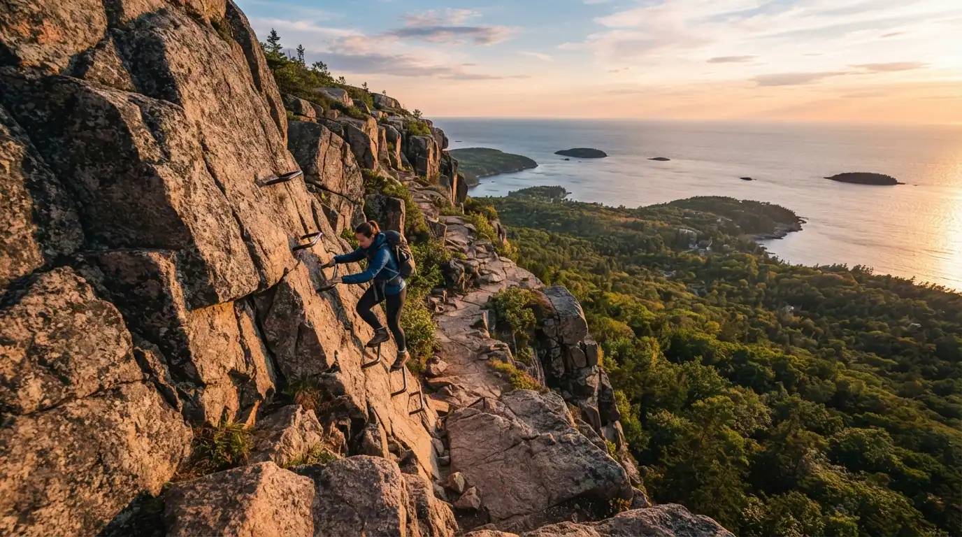
The Precipice Trail in Acadia National Park is a steep, non technical iron rung climb up the east face of Champlain Mountain, widely considered the toughest and most exposed hike in the park. If you have read three different articles and gotten three different mileage numbers and three different fatality claims, you are not imagining things. This guide sorts fact from noise.
What Is the Precipice Trail in Acadia National Park?
The Precipice Trail combines boulder scrambles, iron ladders, and narrow cliff ledges with no harness, rope, or helmet required. It climbs the east face of Champlain Mountain, a route so exposed that many hikers compare it to a European via ferrata rather than a normal trail.
Where Is It Located?
The trailhead sits directly along Park Loop Road on the eastern side of Mount Desert Island, about a 10 minute drive from downtown Bar Harbor and roughly 2 miles from the Sieur de Monts entrance area.
How Long and How Difficult Is It?
Distance and elevation figures vary by source, generally ranging from 2.1 to 3.4 miles round trip with 1,000 to 1,425 feet of elevation gain packed into under a mile of vertical climbing. The wide range comes down to how each source measures the loop, whether they count the road walk back to the parking lot or just the trail itself. Regardless of which number you land on, expect a hard rated hike with iron rungs, ladders, and exposed cliff sections the entire way up.
How Difficult Is It Compared to the Beehive Trail?
The route is longer, steeper, and more exposed than the Beehive Trail, which has roughly half the elevation gain and a shorter overall distance. Many hikers treat Beehive as a warm up, since finishing it without trouble is a decent sign you are ready for the bigger climb. If you are on the fence about which one to attempt first, doing Beehive earlier in your trip gives you a real feel for iron rung hiking before committing to something longer.
What Should You Know Before You Go?
Is It Safe?
The trail is safe for prepared, physically fit hikers in good weather, but it has been the site of serious injuries and at least one documented fatality. A 2012 incident involved a woman who died from a fall, and it took nearly six hours before she could be flown to the hospital. A 2018 rescue required dozens of workers to carry an injured hiker across a scree field for roughly four hours.
Those numbers matter because they show the real cost of an accident here, not just the abstract idea that the trail is dangerous. The rescues themselves are difficult and slow, since the terrain that makes the hike thrilling also makes it hard for emergency crews to reach anyone quickly. If you have a severe fear of heights, are not in good physical condition, or are hiking with small children, this is genuinely not the trail to test your limits on.
When Is It Closed?
The trail closes every year for peregrine falcon nesting, typically from mid March through mid August. The exact reopening date shifts from year to year depending on when the birds finish nesting, so treat mid August as a rough guideline rather than a locked in date. As of the 2026 season, the trail has remained closed into August in line with recent years, so always check the National Park Service current conditions page before building your itinerary around it.
What Is the Best Time to Hike It?
September and October are widely considered the sweet spot, since the trail is fully open by then, summer crowds have thinned out, and fall foliage adds dramatic color to the views from the top. Locals recommend the third or fourth week of October for peak color in a typical year, though foliage timing shifts slightly season to season, so checking a foliage tracker close to your trip date is worth the extra step.
Early morning starts matter just as much as the season. Arriving by 7 or 8am gives you the best shot at parking and lets you climb the exposed sections before the trail fills up with other hikers waiting their turn on narrow ledges. A common mistake first timers make is showing up mid morning expecting an easy spot, only to find the small lot full and cars already lined up along the road.
How Much Does It Cost to Hike It?
Hiking the trail itself is free. What costs money is entering Acadia National Park, which requires a $35 seven day vehicle pass as of the 2026 fee schedule. If you plan to visit more than once in a year, the $70 Acadia annual pass pays for itself after two trips. Travelers planning to hit other national parks in the same year often find better value in the $80 America the Beautiful pass, which covers Acadia plus every other federal park and public land site in the country.
| Pass Type | Cost | Best For |
| 7 day vehicle pass | $35 | Single visit to Acadia |
| Acadia annual pass | $70 | Multiple Acadia trips in one year |
| America the Beautiful annual pass | $80 | Visiting several national parks in one year |
What Is the Hike Actually Like?
What Happens at the Start?
The hike begins with a formal granite staircase before quickly turning into a boulder scramble, where hikers climb over and under large rocks while following painted blue blazes to stay on route. Within the first tenth of a mile, most hikers hit an early obstacle with two widely spaced iron rungs that acts as a natural gut check. If that section feels too difficult or nerve racking, turning around here is the smart move, since the trail only gets more demanding from that point forward.
What Are the Iron Rungs and Ladders Section Like?
After crossing a wooden bridge and reaching the junction with the Orange and Black Path, the trail turns into a near vertical climb using iron rungs, ladders, and handrails anchored straight into the rock face. Hikers cross narrow, exposed ledges and at least one outward leaning catwalk, all while maintaining three points of contact at every step. This is the section that earns the trail its via ferrata comparison, and it is also, according to most hikers who complete it, the most memorable and rewarding part of the whole climb.
What Views Do You Get From the Summit of Champlain Mountain?
From the top, hikers get panoramic views north across Frenchman Bay and the Porcupine Islands toward Schoodic Peninsula, along with the rooftops of Bar Harbor peeking through the treetops below. Champlain Mountain ranks among the taller peaks in Acadia, and on clear days the summit offers one of the widest ocean views in the entire park. It is a fitting reward after a climb that demands full attention the whole way up.
Should You Hike Down It?
No. Descending is strongly discouraged, since climbing down the iron rungs is significantly more dangerous than climbing up them. Going down means facing each rung and ledge in reverse, with your center of gravity working against you the entire time, which is exactly the kind of situation that leads to falls.
What’s the Best Descent Route From the Summit?
Take the Champlain North Ridge Trail down to the Orange and Black Path, then follow the signs to Park Loop Road rather than looping back through the lower section of the route you climbed. Hikers who backtrack through the boulder field a second time consistently describe it as exhausting with no real safety benefit, since you end up repeating the hardest scrambling section on tired legs.
What Should You Pack?
Bring sturdy hiking boots with good traction, plenty of water, snacks, sunscreen, and a light layer for wind at the summit. Gloves are worth packing if you are hiking in cooler weather, since the iron rungs get cold fast and grip matters more than comfort on this trail.
- Hiking boots or trail shoes with solid tread, never sandals or flip flops
- Water and snacks, since the climb is more strenuous than the short distance suggests
- Sunscreen and a hat, since much of the upper trail sits fully exposed
- A light jacket or windbreaker for the summit
- Gloves in cold weather for grip on the metal rungs
- Microspikes if hiking in early spring or late fall when ice is possible
Hiking poles are not recommended, since most of the climb requires both hands free for the rungs, and poles that cannot collapse into your pack will only get in the way.
How Do You Get to the Precipice Trailhead?
The trailhead sits on Park Loop Road on the eastern side of Mount Desert Island, roughly 10 minutes from Bar Harbor and about 15 minutes from Hulls Cove Visitor Center. The small parking lot holds somewhere between 20 and 22 vehicles depending on the source, and it fills quickly on clear mornings during peak season. Once the lot is full, additional legal parking is allowed in the right hand lane of the one way road, so even a full lot rarely means turning back entirely.
Final Thoughts
The Precipice Trail rewards hikers who respect it and take the time to prepare, from checking current conditions to arriving early and packing the right gear. Go up, never down, hike it in September or October if you can, and treat that first iron rung obstacle as the honest gut check it is meant to be. Done right, it remains one of the most exhilarating and rewarding climbs Acadia National Park has to offer.
FAQs
Can dogs hike the Precipice Trail?
No, dogs are not allowed on the Precipice Trail, even though many other trails throughout Acadia National Park do permit leashed dogs.
Do you need a reservation to hike the Precipice Trail?
No reservation is required for the trail itself, though a separate timed vehicle reservation is needed if you plan to drive up Cadillac Mountain during the same trip.
Can children hike the Precipice Trail?
It is generally recommended for hikers age 12 and older. Small children are strongly discouraged given the exposed climbing sections and complete lack of safety gear.
Is the Precipice Trail one way?
Yes, the trail is hiked in one direction, clockwise going up the iron rungs, both for safety and to keep the narrow ledges moving smoothly for everyone on them.
What happens if you are afraid of heights on the trail?
Even hikers with a mild fear of heights often report finding parts of the climb uncomfortable, so anyone with a significant fear should consider the Beehive Trail instead or skip iron rung hikes entirely.


